×
Parcel Data on Demand - Regrid is Esri's Commercial Partner for Parcel Data
Regrid logo, registered trademark
Link
  • Enterprise

    Regrid parcel data Regrid Parcel Data

    Bulk files delivered in the format your business needs.

    • parcel -data United States Parcel Data
    • canada_nav-menu-icon Canada Parcel Data
    • matched building footprints menu icon Matched Building Footprints
    • matched secondary addresses menu icon Matched Secondary Addresses
    • zoning Standardized Zoning
    • enhanced ownership menu icon Enhanced Ownership

    feature service menu icon Regrid Feature Service

    Get data delivery straight into your Esri-stack, no custom integration required.

    regrid api menu icon Regrid API

    Integrate parcel boundaries & records into your app, SaaS, or map.
    • Parcel and Tiles APIcon Parcel & Tiles API
  • Self Serve

    Regrid Property App menu icon Regrid Property App

    Take Regrid property data wherever you go - available for web, iOS, & Android.

    data-store-2 Shop the Data Store

    Instantly download parcel geometries & associated records, by county and state.

    self-serve parcel api menu icon API Monthly Subscriptions

    Sign up and try this nationwide parcel API, free for 7 days.

    api sandbox icon Interactive API Sandbox

    Explore the API Sandbox with complete feature access to 7 counties plus Puerto Rico.
  • Pricing
  • Markets

    agr-con-for_menu-icon-1 Agriculture, Conservation & Forestry

    Regrid for Architecture, Engineering & Construction Architecture, Engineering & Construction

    Esri environments Esri Users

    Regrid for Broadband and Telecommunication Broadband & Telecommunications

    Regrid for Renewable Energy & Utilities Renewable Energy & Utilities

    Regrid for Logistics & Transportation Logistics & Transportation

    Regrid for State & Federal Government State & Federal Government

    Regrid for Insurance & Finance Insurance & Finance

    Regrid for AI & Machine Learning AI & Machine Learning

    Regrid for Real Estate Real Estate

    Regrid for Academia and Research Nonprofit & Academia

    Regrid's Data With Purpose program - propose your own budget to access land parcel data. 

    Plus sign icon Your Business or Organization

    Regrid’s data spans all industries needing land insight.
  • Resources

    support menu icon Support

    Access documentation & support materials to learn about Regrid data.
    • Support site resource icon Support Site
    • tutorial videos resources icon Tutorial Videos
    • parcel data faqs resources icon Parcel Data FAQs
    • property app faqs Property App FAQs
    • coveragemap_resources_icon Coverage Map
    • land use codes menu item Land Use Codes
    • vacancy data menu icon Vacancy Data
    • Data Currency Data Currency FAQs

    content resources menu icon Content

    Dive into Regrid's world of land parcels & learn about location intelligence.
    • blog resources icon Blog
    • webcasts resources icon Webcasts
    • reports resources icon Reports
    • podcast resources icon Living In The Map

    customers resources icon Customers

    Hear what our customers say have to say & see how they use Regrid data.
    • testimonials resources icon Testimonials
    • Case Studies resources icon Case Studies
  • Contact Us

    Contact a parcel data expert menu icon Contact A Parcel Data Expert

    Contact Regrid parcel data experts to learn more about our offerings.

    Customer Support menu icon Customer Support

    Contact our customer support team & get the help you need.

    testimonials_resources_icon-1 Press & Media Inquires

    Find the information you need & get in touch with our marketing department.
  • Go To Map
Go To Map
  • Enterprise

    Regrid Parcel Data

    • United States Parcel Data
    • Canada Parcel Data
    • Matched Building Footprints
    • Matched Secondary Addresses
    • Standardized Zoning
    • Enhanced Ownership

    Regrid Feature Service

    Regrid API

    • Parcel & Tiles API
  • Self Serve

    Regrid Property App

    Shop the Data Store

    API Monthly Subscriptions

    Interactive API Sandbox

  • Pricing
  • Markets

    Agriculture, Conservation & Forestry

    Architecture, Engineering & Construction

    Esri Users

    Broadband & Telecommunications

    Renewable Energy & Utilities

    Logistics & Transportation

    State & Federal Government

    Insurance & Finance

    AI & Machine Learning

    Real Estate

    Nonprofit & Academia

    Your Business or Organization

  • Resources

    Support

    • Support Site
    • Tutorial Videos
    • Parcel Data FAQs
    • Property App FAQs
    • Coverage Map
    • Land Use Codes
    • Vacancy Data
    • Data Currency FAQs

    Content

    • Blog
    • Webcasts
    • Reports
    • Living In The Map

    Customers

    • Testimonials
    • Case Studies
  • Contact Us

    Contact A Parcel Data Expert

    Customer Support

    Press & Media Inquires

    Link

  • Go To Map

Land Parcel Data Is What We Do

100% United States Land Parcel Coverage Map


At Regrid, we are relentless in its pursuit to collect, standardize and make available to you, parcel land data across the entire United States. Regrid is committed to offering simple, accurate access to property boundaries including land use, ownership, and property information.

us-gov

Unlocking America's Foundation

America is made of land parcels with legal boundaries, owners, assessments, and designated uses. These boundaries surround everything: homes, parks, commercial buildings, farms, and wild places alike. If it’s not happening in the middle of the street, it’s happening on a parcel and Regrid knows parcels better than anyone else.

Regrid Collects Data Direct From The Source

Regrid experts collect & standardize land and parcel data from multiple authorities including government records and other proprietary sources. Combining this data ensures your access to the most accurate, up-to-date information.

Parcel Data Delivered How You Need It

Regrid delivers standardized parcel data through a variety of licenses available in Shapefile, GeoPackage, GeoJSON, CSV, SQL, and Apache Parquet formats via cloud services such as S3 buckets, SFTP directories, Parcel API, and Esri-compatible Regrid Feature Service.

ADD TO CART

Parcel Data Collected & Accessible For Your Needs

At Regrid, we understand that you want exceptional data, excellent service, and fair pricing from a trustworthy partner who values your success and is committed to a long-term relationship. That's precisely what you'll get from us.

Unmatched in Coverage. Unrivaled in Currency. Unparalleled in Completeness.

house-pin

Get Nationwide Parcel Data & Additional Insight

To gain insight and make decisions about land and its activities, it is crucial for your organization to have precise and up-to-date information on the fundamental grid of parcel shapes, ownership, current usage, and other features. Regrid offers this parcel data and more to enable you to achieve remarkable results.
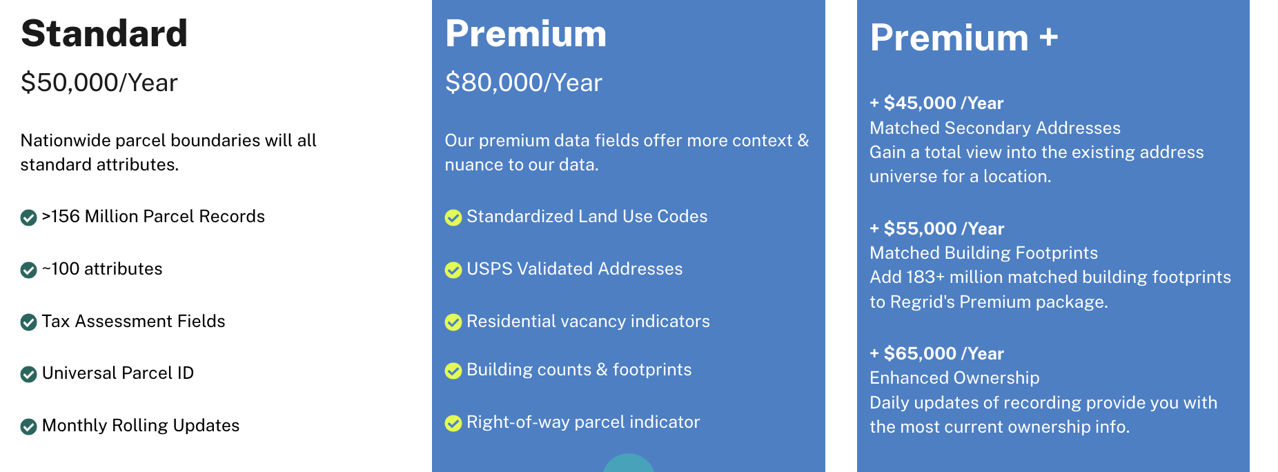
Screen Shot 2023-08-15 at 2.15.51 PM

Fuel Your Business With Fresh, Accurate Parcel Data

Experience The Land Parcel Insight Powered by Regrid’s 3Cs

parcel -data Coverage: Nationwide & Local Insight
Regrid’s parcel coverage spans across every city, county, and state. Explore the insights waiting for you in every corner of the country, including your own street. 

enhanced-ownership-1 Currency: Always Fresh Land Parcel Data

Get the edge of fresh land data precision. Regrid’s parcel data is continuously refreshed, guaranteeing that you have the latest and most dependable nationwide land parcel data. 

parcel-api (1) Completeness: Parcel Boundaries & More!

Explore comprehensive data on land, ownership, buildings, and other related information. Acquire all the pertinent details on each parcel to enable you to make informed decisions.

Get the 3Cs and more when you complete the form next door.

Go for it!

Regrid's Parcel Data Is Trusted by Millions of People & the World's Most Innovative Organizations

CARTO-logo-positive (1)

GIS
CARTO

"Organizations can verify parcel ownership & boundary lines to conduct planning more efficiently."

The Nature Conservancy logo

Environmental
The Nature Conservancy

"Regrid parcel data was the essential starting place for TNC's recent 32,000 acre land acquisition."

Datastory

Location Intelligence
Datastory

"High quality data AND in the right format."

theconservationfund-logo

Environmental
Conservation Fund

"Regrid's Esri-compatible Feature Service have saved us time and money. What used to take 30 minutes to several hours now takes 5 minutes."

Polaris
Ford
USAA-Emblem
AT&T
Münchener Rück
giraffe.build
Dycom_logo
Georgia Pacific
Langan Engineering
The Conservation Fund
Learn More
logo

(888) 4RE-GRID

  • Contact Us
  • Customer Support
  • Privacy Policy
  • Terms of Use

Subscribe for email updates

Company

  • About Regrid
  • Careers
  • Press

Resources

  • Coverage Map
  • Support Center
  • Reports

Support

  • Parcel Data FAQs
  • Property App FAQs
  • Contact Support Team

Customers

  • Customer Stories
  • Case Studies
  • Non Profit & Academia

Enterprise Solutions

  • Nationwide Land Parcels
  • Parcel & Tiles API
  • Feature Service

Self-Serve Solutions

  • Regrid Property App
  • Shop the Data Store
  • API Monthly Plans