×
Parcel Data on Demand - Regrid is Esri's Commercial Partner for Parcel Data
Regrid logo, registered trademark
Link
  • Enterprise

    Regrid parcel data Regrid Parcel Data

    Bulk files delivered in the format your business needs.

    • parcel -data United States Parcel Data
    • canada_nav-menu-icon Canada Parcel Data
    • matched building footprints menu icon Matched Building Footprints
    • matched secondary addresses menu icon Matched Secondary Addresses
    • zoning Standardized Zoning
    • enhanced ownership menu icon Enhanced Ownership

    feature service menu icon Regrid Feature Service

    Get data delivery straight into your Esri-stack, no custom integration required.

    regrid api menu icon Regrid API

    Integrate parcel boundaries & records into your app, SaaS, or map.
    • Parcel and Tiles APIcon Parcel & Tiles API
  • Self Serve

    Regrid Property App menu icon Regrid Property App

    Take Regrid property data wherever you go - available for web, iOS, & Android.

    data-store-2 Shop the Data Store

    Instantly download parcel geometries & associated records, by county and state.

    self-serve parcel api menu icon API Monthly Subscriptions

    Sign up and try this nationwide parcel API, free for 7 days.

    api sandbox icon Interactive API Sandbox

    Explore the API Sandbox with complete feature access to 7 counties plus Puerto Rico.
  • Pricing
  • Markets

    agr-con-for_menu-icon-1 Agriculture, Conservation & Forestry

    Regrid for Architecture, Engineering & Construction Architecture, Engineering & Construction

    Esri environments Esri Users

    Regrid for Broadband and Telecommunication Broadband & Telecommunications

    Regrid for Renewable Energy & Utilities Renewable Energy & Utilities

    Regrid for Logistics & Transportation Logistics & Transportation

    Regrid for State & Federal Government State & Federal Government

    Regrid for Insurance & Finance Insurance & Finance

    Regrid for AI & Machine Learning AI & Machine Learning

    Regrid for Real Estate Real Estate

    Regrid for Academia and Research Nonprofit & Academia

    Regrid's Data With Purpose program - propose your own budget to access land parcel data. 

    Plus sign icon Your Business or Organization

    Regrid’s data spans all industries needing land insight.
  • Resources

    support menu icon Support

    Access documentation & support materials to learn about Regrid data.
    • Support site resource icon Support Site
    • tutorial videos resources icon Tutorial Videos
    • parcel data faqs resources icon Parcel Data FAQs
    • property app faqs Property App FAQs
    • coveragemap_resources_icon Coverage Map
    • land use codes menu item Land Use Codes
    • vacancy data menu icon Vacancy Data
    • Data Currency Data Currency FAQs

    content resources menu icon Content

    Dive into Regrid's world of land parcels & learn about location intelligence.
    • blog resources icon Blog
    • webcasts resources icon Webcasts
    • reports resources icon Reports
    • podcast resources icon Living In The Map

    customers resources icon Customers

    Hear what our customers say have to say & see how they use Regrid data.
    • testimonials resources icon Testimonials
    • Case Studies resources icon Case Studies
  • Contact Us

    Contact a parcel data expert menu icon Contact A Parcel Data Expert

    Contact Regrid parcel data experts to learn more about our offerings.

    Customer Support menu icon Customer Support

    Contact our customer support team & get the help you need.

    testimonials_resources_icon-1 Press & Media Inquires

    Find the information you need & get in touch with our marketing department.
  • Go To Map
Go To Map
  • Enterprise

    Regrid Parcel Data

    • United States Parcel Data
    • Canada Parcel Data
    • Matched Building Footprints
    • Matched Secondary Addresses
    • Standardized Zoning
    • Enhanced Ownership

    Regrid Feature Service

    Regrid API

    • Parcel & Tiles API
  • Self Serve

    Regrid Property App

    Shop the Data Store

    API Monthly Subscriptions

    Interactive API Sandbox

  • Pricing
  • Markets

    Agriculture, Conservation & Forestry

    Architecture, Engineering & Construction

    Esri Users

    Broadband & Telecommunications

    Renewable Energy & Utilities

    Logistics & Transportation

    State & Federal Government

    Insurance & Finance

    AI & Machine Learning

    Real Estate

    Nonprofit & Academia

    Your Business or Organization

  • Resources

    Support

    • Support Site
    • Tutorial Videos
    • Parcel Data FAQs
    • Property App FAQs
    • Coverage Map
    • Land Use Codes
    • Vacancy Data
    • Data Currency FAQs

    Content

    • Blog
    • Webcasts
    • Reports
    • Living In The Map

    Customers

    • Testimonials
    • Case Studies
  • Contact Us

    Contact A Parcel Data Expert

    Customer Support

    Press & Media Inquires

    Link

  • Go To Map

The Regrid Blog

Discover the Latest in Land Parcels & Spatial Data with the Regrid Team!

Regrid Blog

Living In The Map

Categories

  • Announcements
  • Democratizing Data
  • Parcel Data Updates
  • Regrid Updates
  • Product How-To
  • Use Cases
  • Customer & Guest Blogs
  • All About Parcel Data
  • Working at Regrid
  • Regrid 100
  • Reports

Survey Property at Light Speed: Site Control + Street View

Alex Alsup May 6, 2016

Evaluating Property with Site Control + Google Street View

Are you a real estate appraiser who needs to collect parcel-level data on properties and neighborhoods quickly? A city on a tight budget, trying to evaluate housing stock? A researcher collecting data on properties to inform your studies and analysis? If so, we've got a pretty awesome tool for you...

Watch the video below to see how you can use LOVELAND's Site Control to create custom property surveys, evaluate properties via Google Street View, and attach data to the assessment records of any of the more than 115 million parcels LOVELAND has online across the United States.

Now in Site Control: The Street View Surveyor

With Site Control and the Street View Surveyor, you can collect parcel level data on thousands of properties in record time.

But, it's not just Street View imagery at your property surveying fingertips: We can consume imagery via API from other third party street level and oblique / orthogonal imagery providers. If you're working with third-party providers of high resolution imagery, LOVELAND can feed your provider's imagery into Site Control, allowing you to code high resolution imagery in record time.

The LOVELAND Surveyor Interface in Action
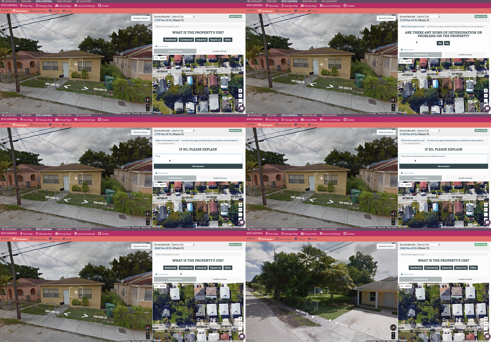
Regrid landsurvey property function

When to Use Street View vs. In-Person Surveying

If you’re thinking, “But Street View is often years old. How can I trust its imagery when I know things change? I don't think it can replace a person who's familiar with the city out surveying in person.”

Trust us, we hear you. Nothing can replace a human in the street evaluating a property, talking to neighbors, and taking up-to-the-moment photography, but that can be an expensive proposition. Surveying via Street View can help you evaluate many properties quickly, and identify the ones that you think need in-person follow up.

When you decide it's time for a surveyor on the ground, they can hit the field with the LOVELAND App and survey using the exact same questions used in your Street View evaluation. This can augment your Street View surveying, giving you an up-to-the-moment understanding of conditions, and collecting insight from neighbors or occupants to gather deeper information on the property.

We want to help you focus your survey personnel on the properties and areas where you know conditions are more dynamic, and the human eye is far mightier than Street View’s.

documenting property condition with Regrid app

Freshness of Street View Imagery

Street View’s drive-thru regularity varies widely, typically based on a city’s size. However, there are many places where LOVELAND has parcel coverage, and Street View drives regularly.

To help those of you who are interested in this tool and wondering how recent the Street View imagery is in your city, we’ve assembled a list of just a few of the major counties & cities where LOVELAND has parcel shapes and data, and Street View imagery is less than a year old.

Some major cities with Street View imagery less than a year old:

  • Dallas, Texas
  • Chicago, Illinois
  • Jacksonville, Florida
  • Tampa, Florida
  • Miami, Florida
  • Houston, Texas
  • Austin, Texas
  • Louisville, Kentucky
  • Columbus, Ohio
  • Pittsburgh, Pennsylvania
  • Milwaukee, Wisconsin
  • San Diego, California
  • Los Angeles, California
  • San Francisco, California
  • Oakland, California
  • Portland, Oregon
  • Seattle, Washington
  • Las Vegas, Nevada
  • Salt Lake City, Utah

If you're curious when Street View imagery was last collected in your city or town, just go to Street View in your area and look in the lower right hand corner of the screen, as you see below:
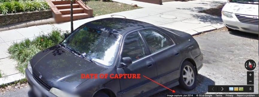
Street view image collection date

Sample Results of a Street View Survey

In the map below, you can explore the results of a very simple one-question property survey conducted over 250 or so parcels on Chicago's South Side.

The job was to answer one question: Is the property vacant? Street View imagery in Chicago is very recent -- circa November 2015 -- so a quick scan of the area can reveal where vacancies are likely, and further follow ups with those properties can happen through in-person surveys of just those parcels, limiting the amount of on-the-ground time and expense.

Thank you, Google

Finally, a word for Google, if you’re out there, thank you for Street View. Its value is tremendous and we believe only beginning to be realized. We hope that we’re playing some small part in demonstrating what it can do. And I couldn’t end this without asking -- Please, pretty please, may we have API access to Street View Time Machine imagery?

That’s when the real fireworks start (#changeovertime).

Thank you from Team LOVELAND.

Previous Next
logo

(888) 4RE-GRID

  • Contact Us
  • Customer Support
  • Privacy Policy
  • Terms of Use

Subscribe for email updates

Company

  • About Regrid
  • Careers
  • Press

Resources

  • Coverage Map
  • Support Center
  • Reports

Support

  • Parcel Data FAQs
  • Property App FAQs
  • Contact Support Team

Customers

  • Customer Stories
  • Case Studies
  • Non Profit & Academia

Enterprise Solutions

  • Nationwide Land Parcels
  • Parcel & Tiles API
  • Feature Service

Self-Serve Solutions

  • Regrid Property App
  • Shop the Data Store
  • API Monthly Plans