×
Parcel Data on Demand - Regrid is Esri's Commercial Partner for Parcel Data
Regrid logo, registered trademark
Link
  • Enterprise

    Regrid parcel data Regrid Parcel Data

    Bulk files delivered in the format your business needs.

    • parcel -data United States Parcel Data
    • canada_nav-menu-icon Canada Parcel Data
    • matched building footprints menu icon Matched Building Footprints
    • matched secondary addresses menu icon Matched Secondary Addresses
    • zoning Standardized Zoning
    • enhanced ownership menu icon Enhanced Ownership

    feature service menu icon Regrid Feature Service

    Get data delivery straight into your Esri-stack, no custom integration required.

    regrid api menu icon Regrid API

    Integrate parcel boundaries & records into your app, SaaS, or map.
    • Parcel and Tiles APIcon Parcel & Tiles API
  • Self Serve

    Regrid Property App menu icon Regrid Property App

    Take Regrid property data wherever you go - available for web, iOS, & Android.

    data-store-2 Shop the Data Store

    Instantly download parcel geometries & associated records, by county and state.

    self-serve parcel api menu icon API Monthly Subscriptions

    Sign up and try this nationwide parcel API, free for 7 days.

    api sandbox icon Interactive API Sandbox

    Explore the API Sandbox with complete feature access to 7 counties plus Puerto Rico.
  • Pricing
  • Markets

    agr-con-for_menu-icon-1 Agriculture, Conservation & Forestry

    Regrid for Architecture, Engineering & Construction Architecture, Engineering & Construction

    Esri environments Esri Users

    Regrid for Broadband and Telecommunication Broadband & Telecommunications

    Regrid for Renewable Energy & Utilities Renewable Energy & Utilities

    Regrid for Logistics & Transportation Logistics & Transportation

    Regrid for State & Federal Government State & Federal Government

    Regrid for Insurance & Finance Insurance & Finance

    Regrid for AI & Machine Learning AI & Machine Learning

    Regrid for Real Estate Real Estate

    Regrid for Academia and Research Nonprofit & Academia

    Regrid's Data With Purpose program - propose your own budget to access land parcel data. 

    Plus sign icon Your Business or Organization

    Regrid’s data spans all industries needing land insight.
  • Resources

    support menu icon Support

    Access documentation & support materials to learn about Regrid data.
    • Support site resource icon Support Site
    • tutorial videos resources icon Tutorial Videos
    • parcel data faqs resources icon Parcel Data FAQs
    • property app faqs Property App FAQs
    • coveragemap_resources_icon Coverage Map
    • land use codes menu item Land Use Codes
    • vacancy data menu icon Vacancy Data
    • Data Currency Data Currency FAQs

    content resources menu icon Content

    Dive into Regrid's world of land parcels & learn about location intelligence.
    • blog resources icon Blog
    • webcasts resources icon Webcasts
    • reports resources icon Reports
    • podcast resources icon Living In The Map

    customers resources icon Customers

    Hear what our customers say have to say & see how they use Regrid data.
    • testimonials resources icon Testimonials
    • Case Studies resources icon Case Studies
  • Contact Us

    Contact a parcel data expert menu icon Contact A Parcel Data Expert

    Contact Regrid parcel data experts to learn more about our offerings.

    Customer Support menu icon Customer Support

    Contact our customer support team & get the help you need.

    testimonials_resources_icon-1 Press & Media Inquires

    Find the information you need & get in touch with our marketing department.
  • Go To Map
Go To Map
  • Enterprise

    Regrid Parcel Data

    • United States Parcel Data
    • Canada Parcel Data
    • Matched Building Footprints
    • Matched Secondary Addresses
    • Standardized Zoning
    • Enhanced Ownership

    Regrid Feature Service

    Regrid API

    • Parcel & Tiles API
  • Self Serve

    Regrid Property App

    Shop the Data Store

    API Monthly Subscriptions

    Interactive API Sandbox

  • Pricing
  • Markets

    Agriculture, Conservation & Forestry

    Architecture, Engineering & Construction

    Esri Users

    Broadband & Telecommunications

    Renewable Energy & Utilities

    Logistics & Transportation

    State & Federal Government

    Insurance & Finance

    AI & Machine Learning

    Real Estate

    Nonprofit & Academia

    Your Business or Organization

  • Resources

    Support

    • Support Site
    • Tutorial Videos
    • Parcel Data FAQs
    • Property App FAQs
    • Coverage Map
    • Land Use Codes
    • Vacancy Data
    • Data Currency FAQs

    Content

    • Blog
    • Webcasts
    • Reports
    • Living In The Map

    Customers

    • Testimonials
    • Case Studies
  • Contact Us

    Contact A Parcel Data Expert

    Customer Support

    Press & Media Inquires

    Link

  • Go To Map

The Regrid Blog

Discover the Latest in Land Parcels & Spatial Data with the Regrid Team!

Regrid Blog

Living In The Map

Categories

  • Announcements
  • Democratizing Data
  • Parcel Data Updates
  • Regrid Updates
  • Product How-To
  • Use Cases
  • Customer & Guest Blogs
  • All About Parcel Data
  • Working at Regrid
  • Regrid 100
  • Reports
New API Feature plus Live event with Geoawesomeness

New API Feature, Search by Polygon - September 2021 Update

Team Regrid September 15, 2021


Visit Regrid.com

New API Feature + Live Event with Geoawesomeness - This is Regrid's September Update.


It's almost the end of Q3! Can you believe it, this year has just flown by.
But we aren't slowing down. We have a host of updates for you right now and we have a couple of big product launches coming up, later this month and next. 

Let's dive into our September update, which features a new update to our API, and an invitation to a virtual event featuring our Chief Data Officer, Matt Hampel, hosted by Geoawesomeness.


Product Update:

1.  Search our Parcel API by Polygon

You asked and we listened.

Many of our API customers have been asking for the ability to search API by polygon or simply put, to be able to search by area, using a GeoJSON input.

Whether you use our self-serve SaaS API solution or bundle our API with our bulk data files, you will now be able to do just that.

Your input will be the polygon's GeoJSON geometry and you will get an array of GeoJSON features containing the matched parcel records as the output. 

At Regrid, we believe in making sure we can serve a multitude of use cases and with these upcoming product features and launches, that is exactly what we are looking to deliver.

Your vision, your use case, our enhanced location context!

Learn more about using our API and searching by polygon here -  API Documentation

If you're interested in our Parcel API and Tileserver, reach out to us today and get a trial token. 

Contact sales button


Upcoming Event:
Join us and the team of Geoawesomeness on our upcoming virtual live event - 


Virtual Event AI needs data normalization: dealing with disparate public data at scale.


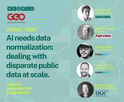
We've put together a stellar panel for this event as we discuss the importance of standardization when working with disparate public datasets. 

We have all heard and read about the difficulties public organizations and health agencies have had sharing spatial data with each other due to a myriad of issues. Working with public datasets at scale is a challenge. For many of us, it involves finding, cleaning, and standardizing disparate local datasets from over 3000 counties just in the USA. Now imagine the complexities across national boundaries and with the data structure in each county. Every county and state does its data differently, and there is no one standard for normalizing this data... And it's a deeply human problem -- AI just won't cut it. 

Here's a quick look at the panel:

1. Matt Hampel (Regrid's Chief Data Officer) - 'Falsehoods Programs Believe About Parcels'
2. Nancy von Meyer (President, Fairview Industries) - 'The Parcel Challenge: Making the Complex Simple'
3.  Pablo Fuentes & Brendan Collins (Founder and Principal at makepath) - 'Normalizing Public Data at Scale'
4. Scott Simmons (Open Geospatial Consortium) - 'Ensuring confidence in land administration information'

We are excited to share space with such industry leaders.
You won't want to miss this event.

You can register for the event and join us live this afternoon. Registration is free and all event videos and information with be shared with the registrants.

That's our September update.
Stay tuned for a major product launch towards the end of this month.

Until then, happy mapping.


HAPPY MAPPING!
THE REGRID TEAM

parcels@regrid.com

Regrid TM Logo


Learn more button


Contact sales button

Previous Next
logo

(888) 4RE-GRID

  • Contact Us
  • Customer Support
  • Privacy Policy
  • Terms of Use

Subscribe for email updates

Company

  • About Regrid
  • Careers
  • Press

Resources

  • Coverage Map
  • Support Center
  • Reports

Support

  • Parcel Data FAQs
  • Property App FAQs
  • Contact Support Team

Customers

  • Customer Stories
  • Case Studies
  • Non Profit & Academia

Enterprise Solutions

  • Nationwide Land Parcels
  • Parcel & Tiles API
  • Feature Service

Self-Serve Solutions

  • Regrid Property App
  • Shop the Data Store
  • API Monthly Plans