×
Parcel Data on Demand - Regrid is Esri's Commercial Partner for Parcel Data
Regrid logo, registered trademark
Link
  • Enterprise

    Regrid parcel data Regrid Parcel Data

    Bulk files delivered in the format your business needs.

    • parcel -data United States Parcel Data
    • canada_nav-menu-icon Canada Parcel Data
    • matched building footprints menu icon Matched Building Footprints
    • matched secondary addresses menu icon Matched Secondary Addresses
    • zoning Standardized Zoning
    • enhanced ownership menu icon Enhanced Ownership

    feature service menu icon Regrid Feature Service

    Get data delivery straight into your Esri-stack, no custom integration required.

    regrid api menu icon Regrid API

    Integrate parcel boundaries & records into your app, SaaS, or map.
    • Parcel and Tiles APIcon Parcel & Tiles API
  • Self Serve

    Regrid Property App menu icon Regrid Property App

    Take Regrid property data wherever you go - available for web, iOS, & Android.

    data-store-2 Shop the Data Store

    Instantly download parcel geometries & associated records, by county and state.

    self-serve parcel api menu icon API Monthly Subscriptions

    Sign up and try this nationwide parcel API, free for 7 days.

    api sandbox icon Interactive API Sandbox

    Explore the API Sandbox with complete feature access to 7 counties plus Puerto Rico.
  • Pricing
  • Markets

    agr-con-for_menu-icon-1 Agriculture, Conservation & Forestry

    Regrid for Architecture, Engineering & Construction Architecture, Engineering & Construction

    Esri environments Esri Users

    Regrid for Broadband and Telecommunication Broadband & Telecommunications

    Regrid for Renewable Energy & Utilities Renewable Energy & Utilities

    Regrid for Logistics & Transportation Logistics & Transportation

    Regrid for State & Federal Government State & Federal Government

    Regrid for Insurance & Finance Insurance & Finance

    Regrid for AI & Machine Learning AI & Machine Learning

    Regrid for Real Estate Real Estate

    Regrid for Academia and Research Nonprofit & Academia

    Regrid's Data With Purpose program - propose your own budget to access land parcel data. 

    Plus sign icon Your Business or Organization

    Regrid’s data spans all industries needing land insight.
  • Resources

    support menu icon Support

    Access documentation & support materials to learn about Regrid data.
    • Support site resource icon Support Site
    • tutorial videos resources icon Tutorial Videos
    • parcel data faqs resources icon Parcel Data FAQs
    • property app faqs Property App FAQs
    • coveragemap_resources_icon Coverage Map
    • land use codes menu item Land Use Codes
    • vacancy data menu icon Vacancy Data
    • Data Currency Data Currency FAQs

    content resources menu icon Content

    Dive into Regrid's world of land parcels & learn about location intelligence.
    • blog resources icon Blog
    • webcasts resources icon Webcasts
    • reports resources icon Reports
    • podcast resources icon Living In The Map

    customers resources icon Customers

    Hear what our customers say have to say & see how they use Regrid data.
    • testimonials resources icon Testimonials
    • Case Studies resources icon Case Studies
  • Contact Us

    Contact a parcel data expert menu icon Contact A Parcel Data Expert

    Contact Regrid parcel data experts to learn more about our offerings.

    Customer Support menu icon Customer Support

    Contact our customer support team & get the help you need.

    testimonials_resources_icon-1 Press & Media Inquires

    Find the information you need & get in touch with our marketing department.
  • Go To Map
Go To Map
  • Enterprise

    Regrid Parcel Data

    • United States Parcel Data
    • Canada Parcel Data
    • Matched Building Footprints
    • Matched Secondary Addresses
    • Standardized Zoning
    • Enhanced Ownership

    Regrid Feature Service

    Regrid API

    • Parcel & Tiles API
  • Self Serve

    Regrid Property App

    Shop the Data Store

    API Monthly Subscriptions

    Interactive API Sandbox

  • Pricing
  • Markets

    Agriculture, Conservation & Forestry

    Architecture, Engineering & Construction

    Esri Users

    Broadband & Telecommunications

    Renewable Energy & Utilities

    Logistics & Transportation

    State & Federal Government

    Insurance & Finance

    AI & Machine Learning

    Real Estate

    Nonprofit & Academia

    Your Business or Organization

  • Resources

    Support

    • Support Site
    • Tutorial Videos
    • Parcel Data FAQs
    • Property App FAQs
    • Coverage Map
    • Land Use Codes
    • Vacancy Data
    • Data Currency FAQs

    Content

    • Blog
    • Webcasts
    • Reports
    • Living In The Map

    Customers

    • Testimonials
    • Case Studies
  • Contact Us

    Contact A Parcel Data Expert

    Customer Support

    Press & Media Inquires

    Link

  • Go To Map

The Regrid Blog

Discover the Latest in Land Parcels & Spatial Data with the Regrid Team!

Regrid Blog

Living In The Map

Categories

  • Announcements
  • Democratizing Data
  • Parcel Data Updates
  • Regrid Updates
  • Product How-To
  • Use Cases
  • Customer & Guest Blogs
  • All About Parcel Data
  • Working at Regrid
  • Regrid 100
  • Reports
Renewable Energy - Informed decisions and faster time to market

Renewable Energy - Informed decisions & faster time to market

Sahana Murthy February 5, 2021
Windmills in a grassy field, as far as the eye can see. Blue sky with large, puffy grey clouds.
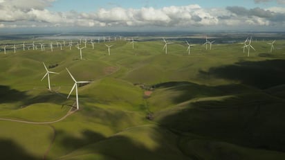
(Photo by Tyler Casey on Unsplash)
 
Get in touch.
 
There is a clean energy revolution happening across the globe right now, with Wind & Solar leading the bandwagon for a better, cleaner & more sustainable future. Sustainable energy generates billions in economic value and is expected to continue growing at a rapid pace in the coming years.
 

More states and cities are expected to increase their decarbonization efforts and more companies are investing in green hydrogen production and storage products. 


What does this mean for businesses operating in renewable energy - more demand, quick data-driven decisions and faster time to market. Let Regrid be that data partner for you!


Informed decisions using high-quality, standardized parcel data:

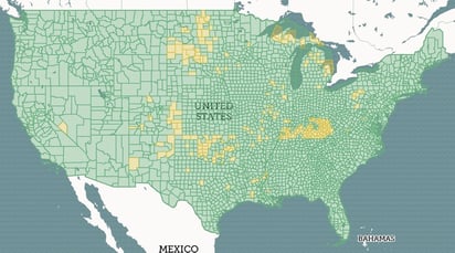
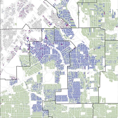
  • Data-driven site selection - Nationwide, standardized, accurate parcel boundaries, acreage, ownership, address (situs & mailing), and standardized land-use codes give you everything you need to make informed decisions faster. 
  • Nationwide standardized land-use codes to expedite your decisions - Parcel data is fundamental to decision making, no matter the size & scale of the project. As we say at Regrid, we are all sitting, standing or walking on a parcel for the most part of our day. That said, there is more to our parcel data than just parcel information, tax assessment data, and shapes (boundaries). Combining standardized parcel data with nuanced & granular land use codes across the country is invaluable.
Let Regrid's nationwide standardized land use code (Land Based Classification System - LBCS) attributes help you further in your site selection process.
 
Whether it is about understanding the activity of a parcel (Eg - Residential LBCS code - 1000, Industrial, manufacturing, and waste-related activities - 3000 etc) or digging deep into the characteristics of the site itself using LBCS_Site (Site that is graded with no structures or active use or Developing site or Developed site with roads, train tracks, and other linear structures or Developed site with tanks, reservoirs, etc), we’ve got you covered.
 
Land along the U-S Mexico Border
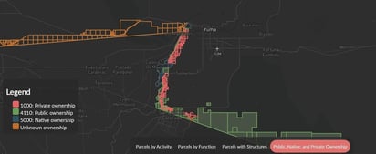
(Pic - Recently released land along the US-Mexico Border Project using our LBCS codes) 
 
  • Universal key for disparate data sources - As fundamental as parcel data is, renewable energy companies will need several other data sources - water lines, geothermal, infrastructure, energy & power grids etc. Let us help you join disparate data sources with our parcel data using matched Placekeys.
Loveland Technologies is one of the founding partners of the Placekey Initiative- the universal location identifier for any physical place in the world. Loveland can append matched placekeys to our parcel data making it easy for you to join parcel information with other data sources. Essentially making the data ingestion & ETL process faster at your end.

Faster time to market with a singular turn-key solution - Regrid Parcel Data! (*updated February 15th, 2022)

  1. Regrid Parcel Data - Standardized nationwide data - ~152* M parcel boundaries with over 120* tax assessments & contextual derivative columns, available in multiple formats & delivered as bulk files for download and/or API to meet your every need.
  Regrid Coverage Map of the United States
 
  1. Regrid Mapping Platform - Parcel data viewer loaded with parcel prospecting (surveying) capabilities through an parcels-on-the-go mobile app for an expedited, data-driven site selection process.
Access our deeper derivative columns, part of our premium data tier.
 
  1. Premium contextual columns -  Access our deeper, contextual derivative columns, which are part of our premium data tier:
  • USPS vacancy & residential indicators
  • Standardized land-use codes 
  • Buildings footprints derivatives - count per parcel & footprints square footage
  1. Buildings Footprints for your solar projects -  >156 M building footprints matched against our parcel data in addition to our dataset for your solar projects. We are the one-stop-shop for all things parcel & land data. :)
  2. and even more as of 2022!

All this at an affordable price.

Like we said, ONE Turn-Key solution for your clean energy projects.

Email us today at parcels@regrid.com to get a data sample!


Get in Touch


Previous Next
logo

(888) 4RE-GRID

  • Contact Us
  • Customer Support
  • Privacy Policy
  • Terms of Use

Subscribe for email updates

Company

  • About Regrid
  • Careers
  • Press

Resources

  • Coverage Map
  • Support Center
  • Reports

Support

  • Parcel Data FAQs
  • Property App FAQs
  • Contact Support Team

Customers

  • Customer Stories
  • Case Studies
  • Non Profit & Academia

Enterprise Solutions

  • Nationwide Land Parcels
  • Parcel & Tiles API
  • Feature Service

Self-Serve Solutions

  • Regrid Property App
  • Shop the Data Store
  • API Monthly Plans