×
Parcel Data on Demand - Regrid is Esri's Commercial Partner for Parcel Data
Regrid logo, registered trademark
Link
  • Enterprise

    Regrid parcel data Regrid Parcel Data

    Bulk files delivered in the format your business needs.

    • parcel -data United States Parcel Data
    • canada_nav-menu-icon Canada Parcel Data
    • matched building footprints menu icon Matched Building Footprints
    • matched secondary addresses menu icon Matched Secondary Addresses
    • zoning Standardized Zoning
    • enhanced ownership menu icon Enhanced Ownership

    feature service menu icon Regrid Feature Service

    Get data delivery straight into your Esri-stack, no custom integration required.

    regrid api menu icon Regrid API

    Integrate parcel boundaries & records into your app, SaaS, or map.
    • Parcel and Tiles APIcon Parcel & Tiles API
  • Self Serve

    Regrid Property App menu icon Regrid Property App

    Take Regrid property data wherever you go - available for web, iOS, & Android.

    data-store-2 Shop the Data Store

    Instantly download parcel geometries & associated records, by county and state.

    self-serve parcel api menu icon API Monthly Subscriptions

    Sign up and try this nationwide parcel API, free for 7 days.

    api sandbox icon Interactive API Sandbox

    Explore the API Sandbox with complete feature access to 7 counties plus Puerto Rico.
  • Pricing
  • Markets

    agr-con-for_menu-icon-1 Agriculture, Conservation & Forestry

    Regrid for Architecture, Engineering & Construction Architecture, Engineering & Construction

    Esri environments Esri Users

    Regrid for Broadband and Telecommunication Broadband & Telecommunications

    Regrid for Renewable Energy & Utilities Renewable Energy & Utilities

    Regrid for Logistics & Transportation Logistics & Transportation

    Regrid for State & Federal Government State & Federal Government

    Regrid for Insurance & Finance Insurance & Finance

    Regrid for AI & Machine Learning AI & Machine Learning

    Regrid for Real Estate Real Estate

    Regrid for Academia and Research Nonprofit & Academia

    Regrid's Data With Purpose program - propose your own budget to access land parcel data. 

    Plus sign icon Your Business or Organization

    Regrid’s data spans all industries needing land insight.
  • Resources

    support menu icon Support

    Access documentation & support materials to learn about Regrid data.
    • Support site resource icon Support Site
    • tutorial videos resources icon Tutorial Videos
    • parcel data faqs resources icon Parcel Data FAQs
    • property app faqs Property App FAQs
    • coveragemap_resources_icon Coverage Map
    • land use codes menu item Land Use Codes
    • vacancy data menu icon Vacancy Data
    • Data Currency Data Currency FAQs

    content resources menu icon Content

    Dive into Regrid's world of land parcels & learn about location intelligence.
    • blog resources icon Blog
    • webcasts resources icon Webcasts
    • reports resources icon Reports
    • podcast resources icon Living In The Map

    customers resources icon Customers

    Hear what our customers say have to say & see how they use Regrid data.
    • testimonials resources icon Testimonials
    • Case Studies resources icon Case Studies
  • Contact Us

    Contact a parcel data expert menu icon Contact A Parcel Data Expert

    Contact Regrid parcel data experts to learn more about our offerings.

    Customer Support menu icon Customer Support

    Contact our customer support team & get the help you need.

    testimonials_resources_icon-1 Press & Media Inquires

    Find the information you need & get in touch with our marketing department.
  • Go To Map
Go To Map
  • Enterprise

    Regrid Parcel Data

    • United States Parcel Data
    • Canada Parcel Data
    • Matched Building Footprints
    • Matched Secondary Addresses
    • Standardized Zoning
    • Enhanced Ownership

    Regrid Feature Service

    Regrid API

    • Parcel & Tiles API
  • Self Serve

    Regrid Property App

    Shop the Data Store

    API Monthly Subscriptions

    Interactive API Sandbox

  • Pricing
  • Markets

    Agriculture, Conservation & Forestry

    Architecture, Engineering & Construction

    Esri Users

    Broadband & Telecommunications

    Renewable Energy & Utilities

    Logistics & Transportation

    State & Federal Government

    Insurance & Finance

    AI & Machine Learning

    Real Estate

    Nonprofit & Academia

    Your Business or Organization

  • Resources

    Support

    • Support Site
    • Tutorial Videos
    • Parcel Data FAQs
    • Property App FAQs
    • Coverage Map
    • Land Use Codes
    • Vacancy Data
    • Data Currency FAQs

    Content

    • Blog
    • Webcasts
    • Reports
    • Living In The Map

    Customers

    • Testimonials
    • Case Studies
  • Contact Us

    Contact A Parcel Data Expert

    Customer Support

    Press & Media Inquires

    Link

  • Go To Map

The Regrid Blog

Discover the Latest in Land Parcels & Spatial Data with the Regrid Team!

Regrid Blog

Living In The Map

Categories

  • Announcements
  • Democratizing Data
  • Parcel Data Updates
  • Regrid Updates
  • Product How-To
  • Use Cases
  • Customer & Guest Blogs
  • All About Parcel Data
  • Working at Regrid
  • Regrid 100
  • Reports

Premium Schema Now Contains Placekey

Matthew Karli March 19, 2024

As a founding partner of Placekey, Regrid is excited to have our parcels attributed with Placekey. Placekey is an identifier for any physical place that was created by the Placekey  team with the stated goal of allowing data pertaining to those places to be shared more easily across organizations.


Launched in late 2020, Placekey was designed to help solve the well known problem related to matching different datasets that were in one way or another related to a place and take into account both the ‘What’ and the ‘Where’ of a place and facilitate the matching of disparate datasets related to those places. While many datasets have a spatial component, with at least one Latitude and Longitude value, matching datasets together with these values is very often imperfect, and certainly imprecise due to even very small variations in the coordinates that allow uncertainty to enter into the picture. Placekey is designed to help solve that problem by providing a common method of link creation and making that common method available to a wide variety of users, at scale for free, or very low cost.


64f70ca4273ee0de38aa3b33_irPTRocDRUT1qkJOQ42Fhye7VcpShK7OLOFo9ItPygo32LJ4xbfe4L4xPN692Oq0Js-0EJ_7QwDFgDQ5Xbq6xOc6npO8976HBGVTUcNjptjFIWPJZl7TZZx0UC3Mcja0__HjoyUOfLJBE8gQYIwdUcdxWw=nw-p-800
The what and the where (from Plackey.io)


Regrid understands that the matching of disparate data types is no trivial matter. We already have several datasets complimentary to parcel boundaries which we have painstakingly directly matched to parcels, and those are currently just a handful of datasets. We recognize the opportunity that still exists to match additional data, even proprietary data, that our customers may need to further their use cases and analysis. As mentioned above, while spatial matching to other spatial datasets is always an option that can be considered, it isn’t always the best manner of matching depending on the nature of the two different datasets. Similarly, tabular matching can be complicated by a variety of factors such as different tabular formats of keys, and that assumes these keys even exist in the first place. Attempts to match on addresses, is very often even more fraught as even very minor differences in the address strings on attempted matches risk significant mis-matching or no matching at all. Addresses in particular are prone to string differences such as minor mis-spellings, variation in how street directionals or suffixes are abbreviated, or not, to name just a few.


Screen Shot 2024-03-18 at 11.09.09 AM

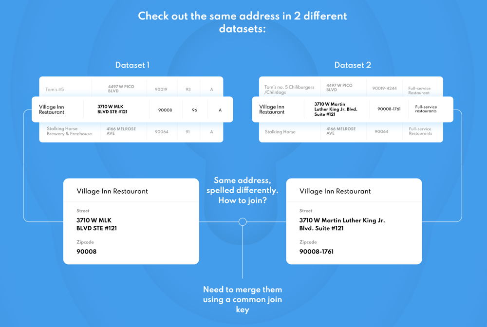
Same address in two different datasets (from Plackey.io)


For this reason Regrid has always been intentional about including a variety of different tabular sources that a user can use to attempt to match to their data. Placekey is just the most recent of these matching keys, and one that we know our customers are using so it made sense for us to add it to our Premium Schema.


If you’re a customer of our Premium Schema and are already familiar with, and utilizing, Placekey in your workflow you are no doubt already seeing the benefits of this added attribute. If you hadn’t heard of Placekey previously and you think it might be a benefit for your business you can learn a lot more by visiting the Placekey website where the team has assembled a great collection of support materials that will get you going.


As always if you have any questions for us drop us a note at parcels@regrid.com and we’ll get back to you promptly.

Previous Next
logo

(888) 4RE-GRID

  • Contact Us
  • Customer Support
  • Privacy Policy
  • Terms of Use

Subscribe for email updates

Company

  • About Regrid
  • Careers
  • Press

Resources

  • Coverage Map
  • Support Center
  • Reports

Support

  • Parcel Data FAQs
  • Property App FAQs
  • Contact Support Team

Customers

  • Customer Stories
  • Case Studies
  • Non Profit & Academia

Enterprise Solutions

  • Nationwide Land Parcels
  • Parcel & Tiles API
  • Feature Service

Self-Serve Solutions

  • Regrid Property App
  • Shop the Data Store
  • API Monthly Plans