


.svg)


.svg)


.png)
Introducing Standardized Zoning
What is Land Use & why does it matter?
Here at Regrid we’ve been in the parcel boundary business for a while, and some members of our team have been in the parcel boundary business, well practically since there was a parcel boundary business. During those years we’ve had the pleasure to talk to a lot of clients and prospects, hear a lot of use cases for parcel boundaries, and we’ve worked closely with both clients and partners on innovative solutions. It’s work that we really enjoy and we’re committed to consistently improving and helping our customers achieve their goals.
Our customer and user community has made it clear that understanding Land Use is a key benefit of parcel boundary data, and that is why we took our first step into this expansive category of attributes back in 2021 when we launched our Land Based Classification Standard attributes, or LBCS for short, at the parcel level. As its name suggests LBCS is a classification system for how a property, or parcel of land is being used. This is an observable metric and can include uses that might not be considered a “use”, such as vacant, or undeveloped property. At the time, and still today, other parcel vendors had solutions for land classification that were one-dimensional. Our approach was more comprehensive as we applied a standard developed by the American Planning Association to apply a five-dimensional standard for land classification bringing greater granularity to land classification than had been applied to parcel data previously.
Once we had our “Land Use” solution for parcel boundaries in the market we quickly started to realize something; Our Land Based Classification Standards, while powerful and beneficial to a lot of users it didn’t completely solve for use cases where understanding both how a property was being used, and how a property could potentially be used. We were missing a key component, at least in part, and it manifested itself in the form of a question that customers and prospects were asking; “Do you have zoning data?”
The simple and straightforward answer to this question was, “Yes!”, as we had a few zoning related fields in our data, one which captured the zoning code from the county, and one which provided a locally sourced description. However, what we learned through conversation was that while that was nice it didn’t really solve all their problems as those fields had dramatic variation not just across the country, but even from county to county, or municipality to municipality! The lack of standardization also made utilizing zoning data assigned to parcels quite difficult and nearly impossible once you got out of a very limited geographic area and leveraging at a Nation, State, and often even regionally was not possible. We lacked zoning data at a usable scale.
What we quickly realized was that the term “Land Use” was more broad than we realized and simply accounting for the classification of a property's use, based on what you could observe, was only part of the story. And our customers and prospects recognized it as well, and that’s why so many of them asked us, as they had found that there were no other solutions in the market that could get beyond this Land Classification limitation either - we found ourselves stuck alongside our peers with a nice Land Classification system, which while powerful, beneficial, and generally referred to as a “Land Use” solution within the industry was in many ways lacking.
Land Classification = 'What is currently happening on a piece of land’
Zoning = 'What could happen on a piece of land’
What was lacking was caught up in that question we were being asked, “Do you have zoning data”, because in numerous instances the future use of the property might be determined or otherwise impacted by often complex zoning provisions that were not necessarily easy to acquire, understand, or apply to properties at scale. Customers recognized this, and this lack of understanding presented them with a non-trivial speed bump to the forward progress of their business. They needed a truly complete solution for Land Use. They needed to know both what was currently happening: Land Classification, and what could happen in the future: Zoning. Only these two items combined could provide a true insight into Comprehensive Land Use.
Parcel Level Land Classification
+ Parcel Level Standardized Zoning
Complete Land Use Solutions
Launching Standardized Zoning Dataset - Add-on to Regrid’s Premium Parcel Data
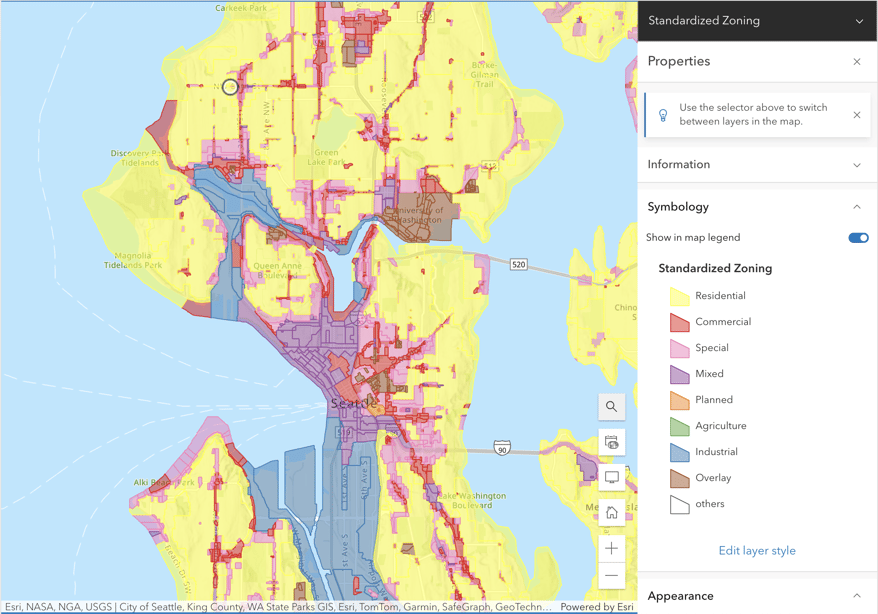
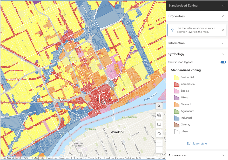
That’s why Regrid is thrilled to announce our newest data product - ‘Standardized Zoning’, an add-on to our Premium Parcel Data Schema, that will empower users with a complete view of Land Use and present both the Land Classification and the Zoning components that are needed - all empowered at the parcel level for granular location intelligence related to Land Use. The details of this product are:
- A Spatial Layer product with attribution associated with individual Zoning boundaries
- Rich attribution for comparing and querying data at scale (over 25 unique attributes)
- Standardization of Zoning Type and Subtype to level comparisons across geographies
- Deliverable in all the spatial formats you are already familiar with through our parcel data
- Flexible access through Bulk data delivery, Feature Service, API, and the Regrid Store
Standardized Zoning Type and Sub-Types in Regrid’s Premium Parcel Data Schema
In addition to the exciting new add-on product, Regrid is also enhancing our parcel data Premium Schema with new attribution related to Zoning. Joining our raw zoning and zoning_description field are new fields for Standardized Zoning Type, Standardized Zoning Subtype, a unique Zoning ID for linking directly to parcels, and a Zoning Date field representing when the zoning database was last updated. These enhancements are already available to all Regrid Parcel Data Premium Schema customers, through all delivery methods. Pro and Team Accounts on the Regrid App are also already seeing the additions of these new Zoning insights. With this update, your land use journey BEGINS with Regrid’s Premium Schema.
Watch this space in coming weeks as we dig deeper into this topic. Regrid understands the complexity of different user stories and use cases and that’s why we’ve built our products in such a way that they’ll be able to access the insights they need in ways that fit their business from both a technology and a budgetary perspective. We’re excited to help you and your business unlock Comprehensive Land Use!
