×
Parcel Data on Demand - Regrid is Esri's Commercial Partner for Parcel Data
Regrid logo, registered trademark
Link
  • Enterprise

    Regrid parcel data Regrid Parcel Data

    Bulk files delivered in the format your business needs.

    • parcel -data United States Parcel Data
    • canada_nav-menu-icon Canada Parcel Data
    • matched building footprints menu icon Matched Building Footprints
    • matched secondary addresses menu icon Matched Secondary Addresses
    • zoning Standardized Zoning
    • enhanced ownership menu icon Enhanced Ownership

    feature service menu icon Regrid Feature Service

    Get data delivery straight into your Esri-stack, no custom integration required.

    regrid api menu icon Regrid API

    Integrate parcel boundaries & records into your app, SaaS, or map.
    • Parcel and Tiles APIcon Parcel & Tiles API
  • Self Serve

    Regrid Property App menu icon Regrid Property App

    Take Regrid property data wherever you go - available for web, iOS, & Android.

    data-store-2 Shop the Data Store

    Instantly download parcel geometries & associated records, by county and state.

    self-serve parcel api menu icon API Monthly Subscriptions

    Sign up and try this nationwide parcel API, free for 7 days.

    api sandbox icon Interactive API Sandbox

    Explore the API Sandbox with complete feature access to 7 counties plus Puerto Rico.
  • Pricing
  • Markets

    agr-con-for_menu-icon-1 Agriculture, Conservation & Forestry

    Regrid for Architecture, Engineering & Construction Architecture, Engineering & Construction

    Esri environments Esri Users

    Regrid for Broadband and Telecommunication Broadband & Telecommunications

    Regrid for Renewable Energy & Utilities Renewable Energy & Utilities

    Regrid for Logistics & Transportation Logistics & Transportation

    Regrid for State & Federal Government State & Federal Government

    Regrid for Insurance & Finance Insurance & Finance

    Regrid for AI & Machine Learning AI & Machine Learning

    Regrid for Real Estate Real Estate

    Regrid for Academia and Research Nonprofit & Academia

    Regrid's Data With Purpose program - propose your own budget to access land parcel data. 

    Plus sign icon Your Business or Organization

    Regrid’s data spans all industries needing land insight.
  • Resources

    support menu icon Support

    Access documentation & support materials to learn about Regrid data.
    • Support site resource icon Support Site
    • tutorial videos resources icon Tutorial Videos
    • parcel data faqs resources icon Parcel Data FAQs
    • property app faqs Property App FAQs
    • coveragemap_resources_icon Coverage Map
    • land use codes menu item Land Use Codes
    • vacancy data menu icon Vacancy Data
    • Data Currency Data Currency FAQs

    content resources menu icon Content

    Dive into Regrid's world of land parcels & learn about location intelligence.
    • blog resources icon Blog
    • webcasts resources icon Webcasts
    • reports resources icon Reports
    • podcast resources icon Living In The Map

    customers resources icon Customers

    Hear what our customers say have to say & see how they use Regrid data.
    • testimonials resources icon Testimonials
    • Case Studies resources icon Case Studies
  • Contact Us

    Contact a parcel data expert menu icon Contact A Parcel Data Expert

    Contact Regrid parcel data experts to learn more about our offerings.

    Customer Support menu icon Customer Support

    Contact our customer support team & get the help you need.

    testimonials_resources_icon-1 Press & Media Inquires

    Find the information you need & get in touch with our marketing department.
  • Go To Map
Go To Map
  • Enterprise

    Regrid Parcel Data

    • United States Parcel Data
    • Canada Parcel Data
    • Matched Building Footprints
    • Matched Secondary Addresses
    • Standardized Zoning
    • Enhanced Ownership

    Regrid Feature Service

    Regrid API

    • Parcel & Tiles API
  • Self Serve

    Regrid Property App

    Shop the Data Store

    API Monthly Subscriptions

    Interactive API Sandbox

  • Pricing
  • Markets

    Agriculture, Conservation & Forestry

    Architecture, Engineering & Construction

    Esri Users

    Broadband & Telecommunications

    Renewable Energy & Utilities

    Logistics & Transportation

    State & Federal Government

    Insurance & Finance

    AI & Machine Learning

    Real Estate

    Nonprofit & Academia

    Your Business or Organization

  • Resources

    Support

    • Support Site
    • Tutorial Videos
    • Parcel Data FAQs
    • Property App FAQs
    • Coverage Map
    • Land Use Codes
    • Vacancy Data
    • Data Currency FAQs

    Content

    • Blog
    • Webcasts
    • Reports
    • Living In The Map

    Customers

    • Testimonials
    • Case Studies
  • Contact Us

    Contact A Parcel Data Expert

    Customer Support

    Press & Media Inquires

    Link

  • Go To Map

The Regrid Blog

Discover the Latest in Land Parcels & Spatial Data with the Regrid Team!

Regrid Blog

Living In The Map

Categories

  • Announcements
  • Democratizing Data
  • Parcel Data Updates
  • Regrid Updates
  • Product How-To
  • Use Cases
  • Customer & Guest Blogs
  • All About Parcel Data
  • Working at Regrid
  • Regrid 100
  • Reports
December 2021 Parcel Data Update

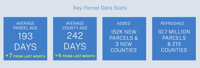
December Parcel Update 2021

The Regrid Data Team December 6, 2021

Key Parcel Data Stats for December 2021

Dear Friends of Regrid Parcel Data and Regrid.com,


A detail of updates in November of 2021 and the upcoming pipeline is below. 


Changes to county table "Layer Names"

Some spatial file formats support a "layer name" for use by software applications. In some software applications, layer names with a dash character, " - " require an additional step during processing. We will be updating our exports to convert dashes, to underscore " _ " characters in layer names starting in January of 2022. Underscore characters are better supported in software applications. Please let us know if you have any feedback or suggestions related to this change.


Loveland Parcel Record Schema changes coming!

We are adding more attribute columns to our Parcel Record Schema in the next 30 - 40 days. We will provide updates in these monthly bulk data emails when they are fully added. More details on these fields can be found at the Data Dictionary listed below, but the short list is: homestead_exemption, alt_parcelnumb1-3 (total of 3 new columns), parcelnumb_no_formatting, assessor_data_date, township, section, range,census_school_district. We would love any feedback on these proposed attributes you might have.


Loveland 'verse' meta data table schema change.

We have dropped the column 'accuzip_status', and replaced it with 'usps_data_date' column that contains the same information, but is date type field so easier for machine reading.


Cropland Data Layer / Cropscape Data

Our initial process for populating these fields is complete for parcels 10 acres or larger.


USPS Vacancy, Residential indicators: Now updated monthly. Unchanged from last month, next update in December.


Coverage Report: Updated for this month and available here.

Data Dictionary for the Regrid Parcel Record Schema

A machine-readable version of this list is included in the `verse` table available in all the formats above as well as CSV format for use in spreadsheets. To find the latest updates in verse, sort by 'last_refresh' and use the 'filename_stem' column to identify the file.


Data refreshed or added from the county in November and live now:

( Asterisk * indicates newly added county)

--------------------------------------------------

AL - Baldwin, Barbour, Bibb, Blount, Bullock, Butler, Calhoun, Chambers, Cherokee, Chilton, Choctaw, Clarke, Clay, Cleburne, Coffee, Colbert, Conecuh, Coosa, Covington, Crenshaw, Cullman, Dale, DeKalb, Elmore, Etowah, Fayette, Franklin, Geneva, Greene, Henry, Houston, Jackson, Jefferson, Lamar, Lauderdale, Lawrence, Limestone, Lowndes, Macon, Madison, Marengo, Marion, Marshall, Mobile, Monroe, Montgomery, Morgan, Randolph, Shelby, St. Clair, Talladega, Tallapoosa, Tuscaloosa, Walker, Wilcox


CA - Amador, Del Norte, Glenn, Imperial, Kings, Lassen, Napa, Nevada, Plumas, Sutter, Tehama, Yolo


CO - Dolores*, Eagle


FL - Duval, Orange


GU - Guam*


IA - Adair, Adams, Dallas, Monona


ID - Idaho


MI - Alger, Baraga, Crawford*, Gogebic, Kalkaska, Keweenaw, Menominee


MN - Clay


MS - DeSoto, Hinds, Lee


ND - McIntosh


OR - Clackamas, Deschutes


PA - Lancaster, Philadelphia


SC - Beaufort


TX - Bexar


VA - Accomack, Albemarle, Alexandria, Alleghany, Amelia, Amherst, Appomattox, Arlington, Augusta, Bath, Bedford, Botetourt, Bristol, Brunswick, Buchanan, Buckingham, Campbell, Caroline, Carroll, Charles City, Charlottesville, Chesapeake, Chesterfield, Clarke, Colonial Heights, Covington, Culpeper, Danville, Dinwiddie, Emporia, Essex, Fairfax, Fairfax City, Falls Church, Floyd, Fluvanna, Franklin, Franklin City, Frederick, Fredericksburg, Galax, Giles, Gloucester, Goochland, Grayson, Greene, Greensville, Halifax, Hampton, Hanover, Harrisonburg, Henrico, Henry, Highland, Hopewell, Isle of Wight, James City, King and Queen, King George, King William, Lancaster, Lexington, Loudoun, Louisa, Lunenburg, Lynchburg, Madison, Manassas, Manassas Park, Mathews, Mecklenburg, Middlesex, Nelson, New Kent, Newport News, Northampton, Norton, Nottoway, Orange, Page, Patrick, Pittsylvania, Poquoson, Portsmouth, Powhatan, Prince Edward, Prince George, Prince William, Pulaski, Radford, Richmond, Richmond City, Roanoke, Roanoke City, Rockbridge, Russell, Salem, Scott, Shenandoah, Smyth, Southampton, Spotsylvania, Stafford, Staunton, Suffolk, Surry, Sussex, Tazewell, Warren, Washington, Waynesboro, Westmoreland, Winchester, Wise, Wythe, York


WA - Stevens


WI - Milwaukee


In the current pipeline for updating in December 2021

--------------------------------------------------

Florida

Illinois

Mississippi


In the pipeline for updating in January 2022

--------------------------------------------------

Hawaii

Pennsylvania

Washington


Based on feedback and county challenges, pipeline planning is always subject to change. As always, please contact us if you have any questions about accessing or using the data, if you find issues with any of our data, or you have any comments or questions about our data in specific areas or states. We also love to hear from you about which counties or regions you’d like to see us update next, as it helps inform our planning process.


Thank you for being a part of Regrid!


Best wishes,
The Regrid Data Team

tech@regrid.com


Regrid TM


Previous Next
logo

(888) 4RE-GRID

  • Contact Us
  • Customer Support
  • Privacy Policy
  • Terms of Use

Subscribe for email updates

Company

  • About Regrid
  • Careers
  • Press

Resources

  • Coverage Map
  • Support Center
  • Reports

Support

  • Parcel Data FAQs
  • Property App FAQs
  • Contact Support Team

Customers

  • Customer Stories
  • Case Studies
  • Non Profit & Academia

Enterprise Solutions

  • Nationwide Land Parcels
  • Parcel & Tiles API
  • Feature Service

Self-Serve Solutions

  • Regrid Property App
  • Shop the Data Store
  • API Monthly Plans