×
Parcel Data on Demand - Regrid is Esri's Commercial Partner for Parcel Data
Regrid logo, registered trademark
Link
  • Enterprise

    Regrid parcel data Regrid Parcel Data

    Bulk files delivered in the format your business needs.

    • parcel -data United States Parcel Data
    • canada_nav-menu-icon Canada Parcel Data
    • matched building footprints menu icon Matched Building Footprints
    • matched secondary addresses menu icon Matched Secondary Addresses
    • zoning Standardized Zoning
    • enhanced ownership menu icon Enhanced Ownership

    feature service menu icon Regrid Feature Service

    Get data delivery straight into your Esri-stack, no custom integration required.

    regrid api menu icon Regrid API

    Integrate parcel boundaries & records into your app, SaaS, or map.
    • Parcel and Tiles APIcon Parcel & Tiles API
  • Self Serve

    Regrid Property App menu icon Regrid Property App

    Take Regrid property data wherever you go - available for web, iOS, & Android.

    data-store-2 Shop the Data Store

    Instantly download parcel geometries & associated records, by county and state.

    self-serve parcel api menu icon API Monthly Subscriptions

    Sign up and try this nationwide parcel API, free for 7 days.

    api sandbox icon Interactive API Sandbox

    Explore the API Sandbox with complete feature access to 7 counties plus Puerto Rico.
  • Pricing
  • Markets

    agr-con-for_menu-icon-1 Agriculture, Conservation & Forestry

    Regrid for Architecture, Engineering & Construction Architecture, Engineering & Construction

    Esri environments Esri Users

    Regrid for Broadband and Telecommunication Broadband & Telecommunications

    Regrid for Renewable Energy & Utilities Renewable Energy & Utilities

    Regrid for Logistics & Transportation Logistics & Transportation

    Regrid for State & Federal Government State & Federal Government

    Regrid for Insurance & Finance Insurance & Finance

    Regrid for AI & Machine Learning AI & Machine Learning

    Regrid for Real Estate Real Estate

    Regrid for Academia and Research Nonprofit & Academia

    Regrid's Data With Purpose program - propose your own budget to access land parcel data. 

    Plus sign icon Your Business or Organization

    Regrid’s data spans all industries needing land insight.
  • Resources

    support menu icon Support

    Access documentation & support materials to learn about Regrid data.
    • Support site resource icon Support Site
    • tutorial videos resources icon Tutorial Videos
    • parcel data faqs resources icon Parcel Data FAQs
    • property app faqs Property App FAQs
    • coveragemap_resources_icon Coverage Map
    • land use codes menu item Land Use Codes
    • vacancy data menu icon Vacancy Data
    • Data Currency Data Currency FAQs

    content resources menu icon Content

    Dive into Regrid's world of land parcels & learn about location intelligence.
    • blog resources icon Blog
    • webcasts resources icon Webcasts
    • reports resources icon Reports
    • podcast resources icon Living In The Map

    customers resources icon Customers

    Hear what our customers say have to say & see how they use Regrid data.
    • testimonials resources icon Testimonials
    • Case Studies resources icon Case Studies
  • Contact Us

    Contact a parcel data expert menu icon Contact A Parcel Data Expert

    Contact Regrid parcel data experts to learn more about our offerings.

    Customer Support menu icon Customer Support

    Contact our customer support team & get the help you need.

    testimonials_resources_icon-1 Press & Media Inquires

    Find the information you need & get in touch with our marketing department.
  • Go To Map
Go To Map
  • Enterprise

    Regrid Parcel Data

    • United States Parcel Data
    • Canada Parcel Data
    • Matched Building Footprints
    • Matched Secondary Addresses
    • Standardized Zoning
    • Enhanced Ownership

    Regrid Feature Service

    Regrid API

    • Parcel & Tiles API
  • Self Serve

    Regrid Property App

    Shop the Data Store

    API Monthly Subscriptions

    Interactive API Sandbox

  • Pricing
  • Markets

    Agriculture, Conservation & Forestry

    Architecture, Engineering & Construction

    Esri Users

    Broadband & Telecommunications

    Renewable Energy & Utilities

    Logistics & Transportation

    State & Federal Government

    Insurance & Finance

    AI & Machine Learning

    Real Estate

    Nonprofit & Academia

    Your Business or Organization

  • Resources

    Support

    • Support Site
    • Tutorial Videos
    • Parcel Data FAQs
    • Property App FAQs
    • Coverage Map
    • Land Use Codes
    • Vacancy Data
    • Data Currency FAQs

    Content

    • Blog
    • Webcasts
    • Reports
    • Living In The Map

    Customers

    • Testimonials
    • Case Studies
  • Contact Us

    Contact A Parcel Data Expert

    Customer Support

    Press & Media Inquires

    Link

  • Go To Map

The Regrid Blog

Discover the Latest in Land Parcels & Spatial Data with the Regrid Team!

Regrid Blog

Living In The Map

Categories

  • Announcements
  • Democratizing Data
  • Parcel Data Updates
  • Regrid Updates
  • Product How-To
  • Use Cases
  • Customer & Guest Blogs
  • All About Parcel Data
  • Working at Regrid
  • Regrid 100
  • Reports

Buildings Footprints & Counts on Landgrid.com

Sahana Murthy January 21, 2020

This January, we have a bunch of updates for you!
So let’s jump right in!

1. Buildings count per parcel & Buildings Footprints:
Last year, we partnered with Gateway Spatial LLC - a fellow mapping company that has successfully collected around 104 million buildings footprints so far & counting, directly from counties, just like how we obtain our parcel data. So it made perfect sense for us to partner together on our solutions.

Using their data, the LOVELAND team has derived & added the following columns to our data:

  • Building counts per parcel. 
  • Building sq footage per parcel (In progress, will be fully added by end of this week). 
  • Map Layer - We’ve also rendered Gateway Spatial’s buildings footprints as a map layer to the Landgrid mapping platform. This premium layer and the above 2 derived attributes are available only to Landgrid Pro & Enterprise customers.

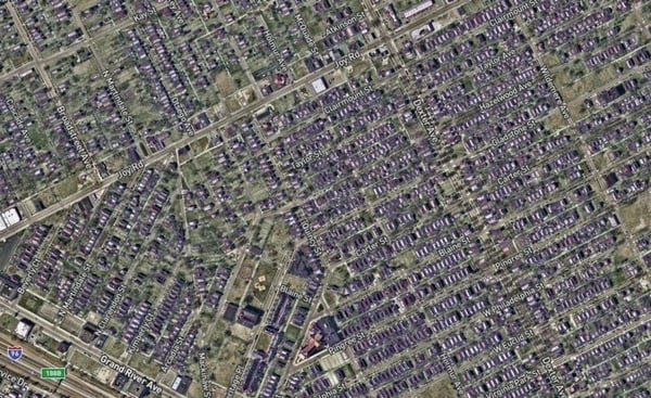
Below is a screenshot of map layer against our parcel data on landgrid.com!
Imagine being able to filter number of buildings per parcel on the Landgrid platform!!


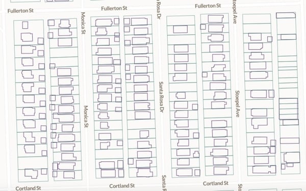
This is a big leap for us parcel data folks. With this data, we can now identify & display how much of a parcel is covered by a building and how many buildings are there on a parcel.

The buildings data attributes, much like the USPS data we added last year are considered premium fields in our parcel dataset. If you are interested in licensing this data from us,  please email us at parcels@landgrid.com.

However, please note that all data is not perfect. We have matched 104 million footprints from Gateway Spatial to our 142 million parcels. As a result, we have a ~69% match rate with this dataset. Please read our FAQ’s to understand the specifics of this data & its accuracy (& lack thereof in certain places) - https://support.landgrid.com/articles/parcel-data-faq/

Please let us know when you find discrepancies in this data, for instance, some buildings may have been demolished since this data was recorded. So help us ground truth it by emailing us at team@landgrid.com.


2. Introducing Talking Grid - Landgrid’s new video webcasts
This year, we are starting a new series of monthly live webcasts on all things Landgrid products, data, customers & partners. You can register for these webinars ahead of time and save your spot. We would love a Q&A session with you at the end of each of these webinars.

We are kick starting this with a session dedicated to our parcel data & its coverage.

Episode 1 - Landgrid Parcel Data & Coverage


Tune in for a candid conversation on all things Landgrid Parcel Data.
Meet 2 of our in-house data experts to learn more about our data, coverage, attributes & accuracy!

Matt Hampel - Senior Software Architect
Blake Girardot - Data Manager

Date: Feb 13th, 2PM ET / 11 AM PT

Register here to join us live - https://www.crowdcast.io/e/landgrid-data---overview


3. People of Landgrid Story - Isaac Robb

“Data doesn't make us smarter, but it does keep us more informed.”


Meet Isaac Robb, Director of Urban Projects at the Western Reserve Land Conservancy!
Learn about Isaac’s inspiring journey from an athlete in college to now a successful community builder at WRLC.
https://landgrid.com/pages/isaac-robb

Those are all our updates for January. 
Stay tuned for many more updates  - including improvements to our base map on our platform. 

Until next time, have a wonderful rest of your January.  As always, feel free to reach back to us at team@landgrid.com!

Happy Mapping!

Sahana Muthy

sahana@landgrid.com

Previous Next
logo

(888) 4RE-GRID

  • Contact Us
  • Customer Support
  • Privacy Policy
  • Terms of Use

Subscribe for email updates

Company

  • About Regrid
  • Careers
  • Press

Resources

  • Coverage Map
  • Support Center
  • Reports

Support

  • Parcel Data FAQs
  • Property App FAQs
  • Contact Support Team

Customers

  • Customer Stories
  • Case Studies
  • Non Profit & Academia

Enterprise Solutions

  • Nationwide Land Parcels
  • Parcel & Tiles API
  • Feature Service

Self-Serve Solutions

  • Regrid Property App
  • Shop the Data Store
  • API Monthly Plans