×
Parcel Data on Demand - Regrid is Esri's Commercial Partner for Parcel Data
Regrid logo, registered trademark
Link
  • Enterprise

    Regrid parcel data Regrid Parcel Data

    Bulk files delivered in the format your business needs.

    • parcel -data United States Parcel Data
    • canada_nav-menu-icon Canada Parcel Data
    • matched building footprints menu icon Matched Building Footprints
    • matched secondary addresses menu icon Matched Secondary Addresses
    • zoning Standardized Zoning
    • enhanced ownership menu icon Enhanced Ownership

    feature service menu icon Regrid Feature Service

    Get data delivery straight into your Esri-stack, no custom integration required.

    regrid api menu icon Regrid API

    Integrate parcel boundaries & records into your app, SaaS, or map.
    • Parcel and Tiles APIcon Parcel & Tiles API
  • Self Serve

    Regrid Property App menu icon Regrid Property App

    Take Regrid property data wherever you go - available for web, iOS, & Android.

    data-store-2 Shop the Data Store

    Instantly download parcel geometries & associated records, by county and state.

    self-serve parcel api menu icon API Monthly Subscriptions

    Sign up and try this nationwide parcel API, free for 7 days.

    api sandbox icon Interactive API Sandbox

    Explore the API Sandbox with complete feature access to 7 counties plus Puerto Rico.
  • Pricing
  • Markets

    agr-con-for_menu-icon-1 Agriculture, Conservation & Forestry

    Regrid for Architecture, Engineering & Construction Architecture, Engineering & Construction

    Esri environments Esri Users

    Regrid for Broadband and Telecommunication Broadband & Telecommunications

    Regrid for Renewable Energy & Utilities Renewable Energy & Utilities

    Regrid for Logistics & Transportation Logistics & Transportation

    Regrid for State & Federal Government State & Federal Government

    Regrid for Insurance & Finance Insurance & Finance

    Regrid for AI & Machine Learning AI & Machine Learning

    Regrid for Real Estate Real Estate

    Regrid for Academia and Research Nonprofit & Academia

    Regrid's Data With Purpose program - propose your own budget to access land parcel data. 

    Plus sign icon Your Business or Organization

    Regrid’s data spans all industries needing land insight.
  • Resources

    support menu icon Support

    Access documentation & support materials to learn about Regrid data.
    • Support site resource icon Support Site
    • tutorial videos resources icon Tutorial Videos
    • parcel data faqs resources icon Parcel Data FAQs
    • property app faqs Property App FAQs
    • coveragemap_resources_icon Coverage Map
    • land use codes menu item Land Use Codes
    • vacancy data menu icon Vacancy Data
    • Data Currency Data Currency FAQs

    content resources menu icon Content

    Dive into Regrid's world of land parcels & learn about location intelligence.
    • blog resources icon Blog
    • webcasts resources icon Webcasts
    • reports resources icon Reports
    • podcast resources icon Living In The Map

    customers resources icon Customers

    Hear what our customers say have to say & see how they use Regrid data.
    • testimonials resources icon Testimonials
    • Case Studies resources icon Case Studies
  • Contact Us

    Contact a parcel data expert menu icon Contact A Parcel Data Expert

    Contact Regrid parcel data experts to learn more about our offerings.

    Customer Support menu icon Customer Support

    Contact our customer support team & get the help you need.

    testimonials_resources_icon-1 Press & Media Inquires

    Find the information you need & get in touch with our marketing department.
  • Go To Map
Go To Map
  • Enterprise

    Regrid Parcel Data

    • United States Parcel Data
    • Canada Parcel Data
    • Matched Building Footprints
    • Matched Secondary Addresses
    • Standardized Zoning
    • Enhanced Ownership

    Regrid Feature Service

    Regrid API

    • Parcel & Tiles API
  • Self Serve

    Regrid Property App

    Shop the Data Store

    API Monthly Subscriptions

    Interactive API Sandbox

  • Pricing
  • Markets

    Agriculture, Conservation & Forestry

    Architecture, Engineering & Construction

    Esri Users

    Broadband & Telecommunications

    Renewable Energy & Utilities

    Logistics & Transportation

    State & Federal Government

    Insurance & Finance

    AI & Machine Learning

    Real Estate

    Nonprofit & Academia

    Your Business or Organization

  • Resources

    Support

    • Support Site
    • Tutorial Videos
    • Parcel Data FAQs
    • Property App FAQs
    • Coverage Map
    • Land Use Codes
    • Vacancy Data
    • Data Currency FAQs

    Content

    • Blog
    • Webcasts
    • Reports
    • Living In The Map

    Customers

    • Testimonials
    • Case Studies
  • Contact Us

    Contact A Parcel Data Expert

    Customer Support

    Press & Media Inquires

    Link

  • Go To Map

The Regrid Blog

Discover the Latest in Land Parcels & Spatial Data with the Regrid Team!

Regrid Blog

Living In The Map

Categories

  • Announcements
  • Democratizing Data
  • Parcel Data Updates
  • Regrid Updates
  • Product How-To
  • Use Cases
  • Customer & Guest Blogs
  • All About Parcel Data
  • Working at Regrid
  • Regrid 100
  • Reports

Statewide Georgia Data & Upcoming Product Launches

Sahana Murthy August 5, 2020

Regrid has statewide coverage in Georgia

We are gearing up for a few product announcements coming up later in August and September.
So we are going to keep our August update fairly short. :)
Digging in:


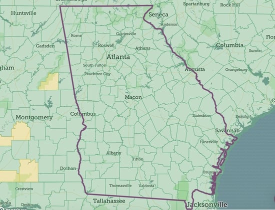
1. Statewide Georgia Data:

We are happy to announce that we now have parcel data for all of Georgia state. If you are looking for statewide GA, please reach out to us at parcels@landgrid.com. While we had some of GA until now, being able to add the rest of the state has surely been a major milestone for us.
If you are looking for individual counties in GA, then the Landgrid data store would be the place to do to for instant downloads of county data in the format of you choice - https://app.regrid.com/store/us/ga

It wasn't just GA that we updated, we recently improved and increased our coverage in MI, ND and are soon looking to add the missing counties in OK as well. 
We are working our way towards reaching complete nationwide data coverage, hopefully by the end of 2020. :)


2. Upcoming Product Announcements:

Landgrid Data API & Tileserver - Self-serve SaaS subscriptions

We recently launched our raster & vector Tileserver as its own stand alone product. Thank you to those who reached out asking for more information on it. We are currently working on making our API & Tileserver subscriptions entirely self-serve like our other SaaS subs - the Data Store and the Landgrid Pro & Team subs. Soon you will be able to pick and choose the API subscription tier that suits your needs best and be on your way to using our API and/or tiles instantly, without any delays. 
Stay tuned, the launch is coming soon. 


Landgrid Pro & Bookmarking on the Landgrid mobile App
We are bulking up our Landgrid mobile app with a comprehensive set of new features.

Soon, you will be able to sign up and use Landgrid Pro straight out of the app and use the same login for the web version as well. Not just that, we are bringing some of our most killer features, including bookmarking properties to the mobile app. 
So you will not only be able to look up properties on the go, but you will be able to bookmark them, add notes to your favorite properties and even take pics of properties that are of most interest to you on the app.

The list doesn’t just stop there. You will soon be able to manage & work on surveys straight out of the app too, along with enjoying some of our pro map layers like buildings footprints & more. 

Phew--- Now that’s a big product update! So, stay tuned, the launch is coming soon. 

3. Upcoming Webcast:
We have an amazing webcast coming up this Friday, August 7th at 3 PM with Kevin Ehrman-Solberg from Mapping Prejudice, an organization that has been doing amazing work mapping racial covenants (restrictions written into deeds that barred non-whites from purchasing the property) and their impacts in Minneapolis and beyond.

Join us live as we sit down to chat with Kevin about racial covenants, data & how crowdsourcing has been critical to gathering this data. We're big fans of Mapping Prejudice here at Loveland, and we encourage all of you to join in and participate.

Register at this link to save your spot for the webinar - https://www.crowdcast.io/e/a-chat-with-mapping

Regrid webinar

In addition to talking about Mapping Prejudice's innovative work crowdsourcing data on racial covenants in Minneapolis, we'll discuss how data has historically been used both as a vehicle for and an ally against racism over time, what currently available data indicates about the state of the nation, as well as what the future may hold.


That’s it from us for now. Please be on the lookout for some launch emails & communications from us. 
Until then, enjoy the rest of your summer.

Please stay safe & well and as always, feel free to reach out to us at team@landgrid.com for all parcel data & mapping information. Or to just say “hi” :)


Happy Mapping!

Team Loveland

http://landgrid.com

team@landgrid.com

313-649-LAND

Previous Next
logo

(888) 4RE-GRID

  • Contact Us
  • Customer Support
  • Privacy Policy
  • Terms of Use

Subscribe for email updates

Company

  • About Regrid
  • Careers
  • Press

Resources

  • Coverage Map
  • Support Center
  • Reports

Support

  • Parcel Data FAQs
  • Property App FAQs
  • Contact Support Team

Customers

  • Customer Stories
  • Case Studies
  • Non Profit & Academia

Enterprise Solutions

  • Nationwide Land Parcels
  • Parcel & Tiles API
  • Feature Service

Self-Serve Solutions

  • Regrid Property App
  • Shop the Data Store
  • API Monthly Plans